Upson County
| County in de Verenigde Staten | |||
|---|---|---|---|
| |||
| Situering | |||
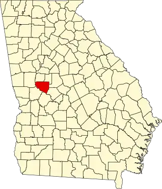
| Staat | Georgia | ||
| Coördinaten | 32°52'48"NB, 84°18'0"WL | ||
| Algemeen | |||
| Oppervlakte | 849 km² | ||
| - land | 843 km² | ||
| - water | 6 km² | ||
| Inwoners (2000) |
27.597 (33 inw./km²) | ||
| Overig | |||
| Zetel | Thomaston | ||
| FIPS-code | 13293 | ||
| Opgericht | 1824 | ||
| Website | www | ||
| Foto's | |||

| |||
 Bevolkingspiramide Upson County | |||
| Statistieken volkstelling Upson County | |||
| |||
Upson County is een county in de Amerikaanse staat Georgia.
De county heeft een landoppervlakte van 843 km² en telt 27.597 inwoners (volkstelling 2000). De hoofdplaats is Thomaston.
Bevolkingsontwikkeling
| Jaar | Inwoners | % ± | |
|---|---|---|---|
| 1900 | 13.670 | — | |
| 1910 | 12.757 | −6,7% | |
| 1920 | 14.786 | 15,9% | |
| 1930 | 19.509 | 31,9% | |
| 1940 | 25.064 | 28,5% | |
| 1950 | 25.078 | 0,1% | |
| 1960 | 23.800 | −5,1% | |
| 1970 | 23.505 | −1,2% | |
| 1980 | 25.998 | 10,6% | |
| 1990 | 26.300 | 1,2% | |
| 2000 | 27.597 | 4,9% | |
| Bron: (en) Historical Decennial Census Population | |||