Tunbridge Wells (district)
| Niet-metropolitaans district in Engeland | |||
|---|---|---|---|
| |||
| Situering | |||
| Land | Engeland | ||
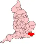
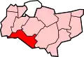
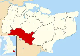
| County | Kent | ||
| Regio | South East England | ||
| Coördinaten | 51°7'44"NB, 0°15'39"OL | ||
| Algemeen | |||
| Oppervlakte | 331,3287[1] km² | ||
| Inwoners (2018[2]) |
118.054 (356 inw./km²) | ||
| ONS-code | E07000116 | ||
| Website | www | ||
| Detailkaart | |||
| |||
| |||
Tunbridge Wells is een Engels district in het shire-graafschap (non-metropolitan county OF county) Kent en telt 118.000 inwoners. De oppervlakte bedraagt 331 km². Hoofdplaats is Tunbridge Wells.
Van de bevolking is 16,3% ouder dan 65 jaar. De werkloosheid bedraagt 1,9% van de beroepsbevolking (cijfers volkstelling 2001).
Plaatsen in district Tunbridge Wells
Civil parishes in district Tunbridge Wells
Benenden, Bidborough, Brenchley, Capel, Cranbrook & Sissinghurst, Frittenden, Goudhurst, Hawkhurst, Horsmonden, Lamberhurst, Paddock Wood, Pembury, Rusthall, Sandhurst, Southborough, Speldhurst.
Bronnen, noten en/of referenties
- ↑ Office for National Statistics → Download → SAM_for_Administrative_Areas_(2018).zip → SAM_LAD_DEC_2018_UK.xlsx.
- ↑ https://www.ons.gov.uk/file?uri=/peoplepopulationandcommunity/populationandmigration/populationestimates/datasets/populationestimatesforukenglandandwalesscotlandandnorthernireland/mid20182019laboundaries/ukmidyearestimates20182019ladcodes.xls Schatting Office for National Statistics: knop MYE5 → kolom Estimated Population mid-2018]