Tumbarumba Shire Council
| Local Government Area van Australië | |||
|---|---|---|---|
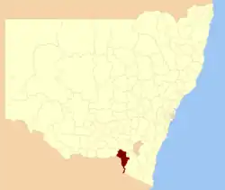 Locatie in New South Wales
| |||
| Situering | |||
| Staat | New South Wales | ||
| Streek | Riverina | ||
| Hoofdplaats | Tumbarumba (Cnr Bridge and Winton Street)[1] | ||
| Coördinaten | 35°45'ZB, 148°0'OL | ||
| Algemene informatie | |||
| Oppervlakte | 4.392[1] km² | ||
| Inwoners | 3.545 | ||
| Politiek | |||
| Burgemeester | David Robertson | ||
| Overig | |||
| Website | http://www.tumbashire.nsw.gov.au | ||
| |||
Tumbarumba Shire Council is een Local Government Area (LGA) in de Australische deelstaat New South Wales. Tumbarumba Shire Council telt 3.545 inwoners. De hoofdplaats is Tumbarumba.
Bronnen, noten en/of referenties
- ↑ a b Tumbarumba Shire Council. Department of Local Government. Geraadpleegd op 8 november 2006.