Tollerton (North Yorkshire)
| Civil parish in Engeland | |||
|---|---|---|---|
.svg.png) | |||
| Situering | |||
| Regio | Yorkshire and the Humber | ||
| Graafschap | North Yorkshire | ||
| District | Hambleton | ||
| Coördinaten | 54° 4' NB, 1° 13' WL | ||
| Algemeen | |||
| Oppervlakte | 8,9164 km² | ||
| Inwoners (2011) |
1026 (115 inw./km²) | ||
| Overig | |||
| Postcode(s) | YO61 | ||
| Netnummer(s) | 01347 | ||
| Grid code | SE512641 | ||
| Post town | YORK | ||
| ONS-code | E04007286 | ||
| Foto's | |||
| |||
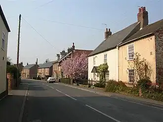
| Tollerton | |||
| |||
Tollerton is een civil parish in het bestuurlijke gebied Hambleton, in het Engelse graafschap North Yorkshire.
Bronnen, noten en/of referenties
Geplaatst op:
4-8-2010
4-8-2010
Dit artikel is een beginnetje over landen & volken. U wordt uitgenodigd om op bewerken te klikken om uw kennis aan dit artikel toe te voegen.