Thanet (district)
| Niet-metropolitaans district in Engeland | |||
|---|---|---|---|
| |||
| Situering | |||
| Land | Engeland | ||
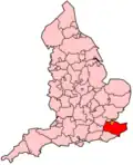
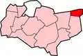
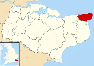
| County | Kent | ||
| Regio | South East England | ||
| Coördinaten | 51°22'8"NB, 1°25'8"OL | ||
| Algemeen | |||
| Oppervlakte | 103,3391[1] km² | ||
| Inwoners (2001) |
126.702 (1226 inw./km²) | ||
| ONS-code | E07000114 | ||
| Website | thanet | ||
| Detailkaart | |||
| |||
| Foto's | |||
.jpg)
| |||
| Thanet van boven gezien | |||
| |||
Thanet is een Engels district in het shire-graafschap (non-metropolitan county OF county) Kent en telt 126.702 inwoners. De oppervlakte bedraagt 103 km².
Van de bevolking is 21,8% ouder dan 65 jaar. De werkloosheid bedraagt 4,4% van de beroepsbevolking (cijfers volkstelling 2001).
Plaatsen in district Thanet
- Broadstairs
- Cliftonville
- Isle of Thanet
- Margate
- Newington
- Palm Bay
- St Peter's
- Westbrook
- Westgate-on-Sea
Civil parishes in district Thanet
Acol, Birchington, Broadstairs and St. Peters, Cliffsend, Manston, Minster, Monkton, Ramsgate, Sarre, St. Nicholas at Wade.
Bronnen, noten en/of referenties
- ↑ Office for National Statistics → Download → SAM_for_Administrative_Areas_(2017).zip → SAM_LAD_DEC_2017_UK.xlsx. Gearchiveerd op 9 mei 2019.