Teton County (Montana)
| County in de Verenigde Staten | |||
|---|---|---|---|
| |||
| Situering | |||
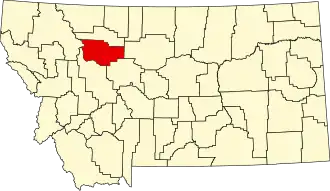
| Staat | Montana | ||
| Coördinaten | 47°51'0"NB, 112°13'48"WL | ||
| Algemeen | |||
| Oppervlakte | 5.938 km² | ||
| - land | 5.886 km² | ||
| - water | 52 km² | ||
| Inwoners (2000) |
6.445 (1 inw./km²) | ||
| Overig | |||
| Zetel | Choteau | ||
| FIPS-code | 30099 | ||
| Opgericht | 1893 | ||
| Website | www | ||
| Foto's | |||

| |||
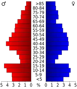 Bevolkingspiramide Teton County | |||
| Statistieken volkstelling Teton County | |||
| |||
Teton County is een county in de Amerikaanse staat Montana.
De county heeft een landoppervlakte van 5.886 km² en telt 6.445 inwoners (volkstelling 2000). De hoofdplaats is Choteau.
Bevolkingsontwikkeling
| Jaar | Inwoners | % ± | |
|---|---|---|---|
| 1900 | 5.080 | — | |
| 1910 | 9.546 | 87,9% | |
| 1920 | 5.870 | −38,5% | |
| 1930 | 6.068 | 3,4% | |
| 1940 | 6.922 | 14,1% | |
| 1950 | 7.232 | 4,5% | |
| 1960 | 7.295 | 0,9% | |
| 1970 | 6.116 | −16,2% | |
| 1980 | 6.491 | 6,1% | |
| 1990 | 6.271 | −3,4% | |
| 2000 | 6.445 | 2,8% | |
| Bron: (en) Historical Decennial Census Population | |||