St. Louis County (Missouri)
| County in de Verenigde Staten | |||
|---|---|---|---|
| |||
| Situering | |||
| Staat | Missouri | ||
| Coördinaten | 38°38'24"NB, 90°26'24"WL | ||
| Algemeen | |||
| Oppervlakte | 1.356 km² | ||
| - land | 1.315 km² | ||
| - water | 41 km² | ||
| Inwoners (2000) |
1.016.315 (773 inw./km²) | ||
| Overig | |||
| Zetel | Clayton | ||
| FIPS-code | 29189 | ||
| Opgericht | 1812 | ||
| Website | stlouiscountymo | ||
| Foto's | |||

| |||
 Bevolkingspiramide St. Louis County | |||
| Statistieken volkstelling St. Louis County | |||
| |||
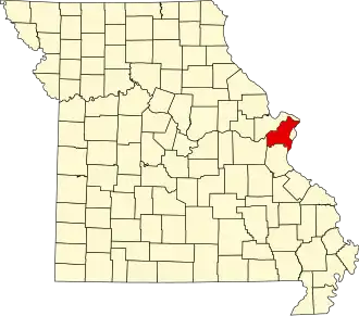
St. Louis County is een county in de Amerikaanse staat Missouri.
De county heeft een landoppervlakte van 1.315 km² en telt 1.016.315 inwoners (volkstelling 2000). De hoofdplaats is Clayton.
St. Louis County ondersteunt het Metropolitan Zoological Park and Museum District.
Bevolkingsontwikkeling
| Jaar | Inwoners | % ± | |
|---|---|---|---|
| 1900 | 50.040 | — | |
| 1910 | 82.417 | 64,7% | |
| 1920 | 100.737 | 22,2% | |
| 1930 | 211.593 | 110,0% | |
| 1940 | 274.230 | 29,6% | |
| 1950 | 406.349 | 48,2% | |
| 1960 | 703.532 | 73,1% | |
| 1970 | 951.353 | 35,2% | |
| 1980 | 973.896 | 2,4% | |
| 1990 | 993.529 | 2,0% | |
| 2000 | 1.016.315 | 2,3% | |
| Bron: (en) Historical Decennial Census Population | |||