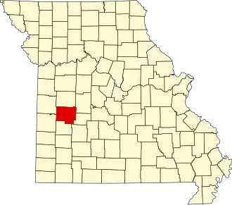
St. Clair County (Missouri)
| County in de Verenigde Staten | |||
|---|---|---|---|
| |||
| Situering | |||
| Staat | Missouri | ||
| Coördinaten | 38°2'24"NB, 93°46'12"WL | ||
| Algemeen | |||
| Oppervlakte | 1.818 km² | ||
| - land | 1.753 km² | ||
| - water | 65 km² | ||
| Inwoners (2000) |
9.652 (6 inw./km²) | ||
| Overig | |||
| Zetel | Osceola | ||
| FIPS-code | 29185 | ||
| Opgericht | 1841 | ||
| Website | www | ||
| Foto's | |||
| |||
 Bevolkingspiramide St. Clair County | |||
| Statistieken volkstelling St. Clair County | |||
| |||
St. Clair County is een county in de Amerikaanse staat Missouri.
De county heeft een landoppervlakte van 1.753 km² en telt 9.652 inwoners (volkstelling 2000). De hoofdplaats is Osceola.
Bevolkingsontwikkeling
| Jaar | Inwoners | % ± | |
|---|---|---|---|
| 1900 | 17.907 | — | |
| 1910 | 16.412 | −8,3% | |
| 1920 | 15.341 | −6,5% | |
| 1930 | 13.289 | −13,4% | |
| 1940 | 13.146 | −1,1% | |
| 1950 | 10.482 | −20,3% | |
| 1960 | 8.421 | −19,7% | |
| 1970 | 7.667 | −9,0% | |
| 1980 | 8.622 | 12,5% | |
| 1990 | 8.457 | −1,9% | |
| 2000 | 9.652 | 14,1% | |
| Bron: (en) Historical Decennial Census Population | |||