St. Clair County (Alabama)
| County in de Verenigde Staten | |||
|---|---|---|---|

| |||
| Situering | |||
| Staat | Alabama | ||
| Coördinaten | 33°42'56,99"NB, 86°19'5,02"WL | ||
| Algemeen | |||
| Oppervlakte | 1.692 km² | ||
| - land | 1.641 km² | ||
| - water | 51 km² | ||
| Inwoners (2000) |
64.742 (39 inw./km²) | ||
| Overig | |||
| Zetel | Ashville | ||
| FIPS-code | 01115 | ||
| Opgericht | 1818 | ||
| Website | www | ||
| Foto's | |||

| |||
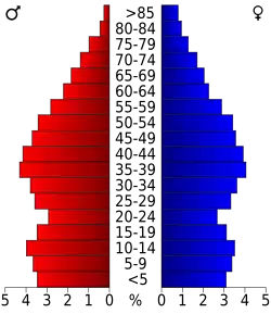 Bevolkingspiramide St. Clair County | |||
| Statistieken volkstelling St. Clair County | |||
| |||
St. Clair County is een county in de Amerikaanse staat Alabama.
De county heeft een landoppervlakte van 1.641 km² en telt 64.742 inwoners (volkstelling 2000). De hoofdplaats is Ashville.
Bevolkingsontwikkeling
| Jaar | Inwoners | % ± | |
|---|---|---|---|
| 1900 | 19.425 | — | |
| 1910 | 20.715 | 6,6% | |
| 1920 | 23.383 | 12,9% | |
| 1930 | 24.510 | 4,8% | |
| 1940 | 27.336 | 11,5% | |
| 1950 | 26.687 | −2,4% | |
| 1960 | 25.388 | −4,9% | |
| 1970 | 27.956 | 10,1% | |
| 1980 | 41.205 | 47,4% | |
| 1990 | 50.009 | 21,4% | |
| 2000 | 64.742 | 29,5% | |
| Bron: (en) Historical Decennial Census Population | |||