Shire of Northampton
| Local Government Area van Australië | |||
|---|---|---|---|
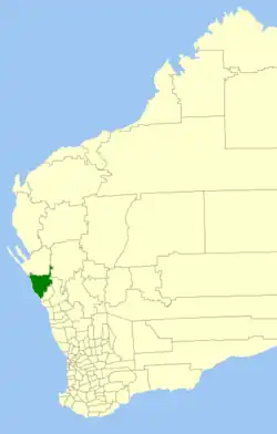 Locatie van Shire of Northampton in West-Australië
| |||
| Situering | |||
| Staat | West-Australië | ||
| Hoofdplaats | Northampton | ||
| Coördinaten | 28°21'4"ZB, 114°37'41"OL | ||
| Algemene informatie | |||
| Oppervlakte | 13.737,8 km² | ||
| Inwoners | 3.227 (2021)[1] | ||
| Overig | |||
| Website | (en) Shire of Northampton | ||
| |||
Shire of Northampton is een lokaal bestuursgebied (LGA) in de regio Mid West in West-Australië.
Geschiedenis
Op 25 januari 1871 werd het Mines Road District gesticht. Op 10 februari 1887 werd het hernoemd naar het Northampton Road District en op 23 juni 1961 ten gevolge de Local Government Act van 1960 tot Shire of Northampton.[2]
Beschrijving
Shire of Northampton ligt 475 kilometer ten noorden van de West-Australische hoofdstad Perth. Het beslaat een oppervlakte van 12.499 km². Er ligt 358 kilometer verharde en 949 kilometer onverharde weg.[3]
In 2021 telde Shire of Northampton 3.227 inwoners. De hoofdplaats is Northampton.
Plaatsen, dorpen en lokaliteiten
- Northampton
- Ajana
- Alma
- Barrel Well Community
- Binnu
- Bowes
- East Bowes
- Horrocks
- Houtman Abrolhos
- Isseka
- Kalbarri
- nationaal park Kalbarri
- Lynton
- Ogilvie
- Port Gregory
- Sandy Gully
- Yallabatharra
Bevolkingsevolutie
| Jaar | Bevolkingsaantal |
|---|---|
| 1911 | 1.412 |
| 1921 | 1.518 |
| 1933 | 1.677 |
| 1947 | 1.470 |
| 1954 | 1.753 |
| 1961 | 1.821 |
| 1966 | 2.021 |
| 1971 | 2.142 |
| 1976 | 2.422 |
| 1981 | 2.366 |
| 1986 | 3.034 |
| 1991 | 3.480 |
| 1996 | 3.697 |
| 2001 | 4.136 |
| 2006 | 4.085 |
| 2016 | 3.319 |
| 2021 | 3.227 |
Bronnen, noten en/of referenties
- ↑ (en) 2021 Census Northampton (LGA). ABS. Geraadpleegd op 26 juli 2022.
- ↑
 (en) Municipality Boundary Amendments Register Release 4.0 10-11. Western Australian Government (31 juli 2011). Geraadpleegd op 18 december 2019.
- ↑ (en) About us. Shire of Northampton. Geraadpleegd op 26 juli 2022.