Santa Luzia d'Oeste
| Gemeente in Brazilië | |||
|---|---|---|---|
  | |||
 | |||
| Situering | |||
| Regio | Noord | ||
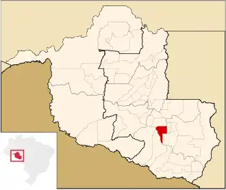
| Staat | Rondônia | ||
| Mesoregio | Leste Rondoniense | ||
| Microregio | Cacoal | ||
| Coördinaten | 11° 51′ ZB, 61° 47′ WL | ||
| Algemeen | |||
| Oppervlakte | 1.187,75 km² | ||
| Inwoners (2009) |
9.348 (7,79 inw./km²) | ||
| Hoogte | 260 m | ||
| Politiek | |||
| Burgemeester | Cloreni Matt | ||
| Gesticht | 11 mei 1986 | ||
| Overig | |||
| Tijdzone | UTC−4 | ||
| HDI | 0,679 | ||
| Website | santaluzia.ro.gov.br | ||
| Detailkaart | |||
| |||
| Locatie van Santa Luzia D'Oeste in de staat Rondônia | |||
| |||
Santa Luzia D'Oeste is een gemeente in de Braziliaanse deelstaat Rondônia. De gemeente telt 9.348 inwoners (schatting 2009).
Bronnen, noten en/of referenties