São Pedro da Cipa
| Gemeente in Brazilië | |||
|---|---|---|---|
 | |||
| Situering | |||
| Regio | Centraal-West | ||
| Staat | Mato Grosso | ||
| Mesoregio | Sudeste Mato-Grossense | ||
| Microregio | Rondonópolis | ||
| Coördinaten | 16° 0′ ZB, 54° 55′ WL | ||
| Algemeen | |||
| Oppervlakte | 344,360 km² | ||
| Inwoners (2009) |
4.241 (10,6 inw./km²) | ||
| Hoogte | 264 m | ||
| Gemeentenummer | 5107404 | ||
| Burgemeester | Daniel Francisco Farias | ||
| Overig | |||
| Tijdzone | UTC−4 | ||
| HDI | 0,717 | ||
| Website | saopedrodacipa.mt.gov.br | ||
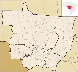
| Detailkaart | |||
| |||
| Locatie van São Pedro da Cipa in de staat Mato Grosso | |||
| |||
São Pedro da Cipa is een gemeente in de Braziliaanse deelstaat Mato Grosso. De gemeente telt 4.241 inwoners (schatting 2009).
Bronnen, noten en/of referenties