São Félix do Coribe
| Gemeente in Brazilië | |||
|---|---|---|---|
  | |||
 | |||
| Situering | |||
| Regio | Noordoost | ||
| Staat | Bahia | ||
| Mesoregio | Extremo Oeste Baiano | ||
| Microregio | Santa Maria da Vitória | ||
| Coördinaten | 13° 24′ ZB, 44° 12′ WL | ||
| Algemeen | |||
| Oppervlakte | 846,123 km² | ||
| Inwoners (2009) |
13.504 (13,8 inw./km²) | ||
| Hoogte | 434 m | ||
| Gemeentenummer | 2929057 | ||
| Politiek | |||
| Burgemeester | Moacir Pimenta Montenegro | ||
| Gesticht | 14 mei 1989 | ||
| Overig | |||
| Tijdzone | UTC−3 | ||
| HDI | 0,683 | ||
| Website | saofelixdocoribe.ba.gov.br | ||
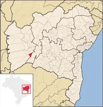
| Detailkaart | |||
| |||
| Locatie van São Félix do Coribe in Bahia | |||
| Foto's | |||
%252C_S%C3%A3o_F%C3%A9lix_do_Coribe%252C_janeiro_de_2017.jpg)
| |||
| Plein aan de hoofdstraat Avenida Ernesto Geisel in São Félix do Coribe | |||
| |||
São Félix do Coribe is een gemeente in de Braziliaanse deelstaat Bahia. De gemeente telt 13.504 inwoners (schatting 2009).
Aangrenzende gemeenten
De gemeente grenst aan Carinhanha, Coribe, Santa Maria da Vitória, Santana en Serra do Ramalho.
Bronnen, noten en/of referenties
Zie de categorie São Félix do Coribe van Wikimedia Commons voor mediabestanden over dit onderwerp.