Rush County (Indiana)
| County in de Verenigde Staten | |||
|---|---|---|---|

| |||
| Situering | |||
| Staat | Indiana | ||
| Coördinaten | 39°37'12"NB, 85°28'12"WL | ||
| Algemeen | |||
| Oppervlakte | 1.058 km² | ||
| - land | 1.057 km² | ||
| - water | 1 km² | ||
| Inwoners (2000) |
18.261 (17 inw./km²) | ||
| Overig | |||
| Zetel | Rushville | ||
| FIPS-code | 18139 | ||
| Opgericht | 1821 | ||
| Website | rushcounty | ||
| Foto's | |||
.jpg)
| |||
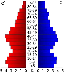 Bevolkingspiramide Rush County | |||
| Statistieken volkstelling Rush County | |||
| |||
Rush County is een county in de Amerikaanse staat Indiana.
De county heeft een landoppervlakte van 1.057 km² en telt 18.261 inwoners (volkstelling 2000). De hoofdplaats is Rushville.
Bevolkingsontwikkeling
| Jaar | Inwoners | % ± | |
|---|---|---|---|
| 1900 | 20.148 | — | |
| 1910 | 19.349 | −4,0% | |
| 1920 | 19.241 | −0,6% | |
| 1930 | 19.412 | 0,9% | |
| 1940 | 18.927 | −2,5% | |
| 1950 | 19.799 | 4,6% | |
| 1960 | 20.393 | 3,0% | |
| 1970 | 20.352 | −0,2% | |
| 1980 | 19.604 | −3,7% | |
| 1990 | 18.129 | −7,5% | |
| 2000 | 18.261 | 0,7% | |
| Bron: (en) Historical Decennial Census Population | |||