Rotherfield Peppard
| Civil parish in Engeland | |||
|---|---|---|---|
 | |||
| Situering | |||
| Regio | South East England | ||
| Graafschap | Oxfordshire | ||
| District | South Oxfordshire | ||
| Coördinaten | 51° 32' NB, 0° 57' WL | ||
| Algemeen | |||
| Oppervlakte | 7,7343 km² | ||
| Inwoners (2011) |
1649 (213 inw./km²) | ||
| Overig | |||
| Postcode(s) | RG9 | ||
| Netnummer(s) | 01491 | ||
| Grid code | SU710815 | ||
| Post town | HENLEY-ON-THAMES | ||
| ONS-code | E04008157 | ||
| Website | www | ||
| Foto's | |||
| |||
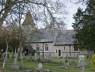
| De kerk van Rotherfield Peppard | |||
| |||
Rotherfield Peppard is een civil parish in het bestuurlijke gebied South Oxfordshire, in het Engelse graafschap Oxfordshire met 1649 inwoners.
Geplaatst op:
5-8-2010
5-8-2010
Dit artikel is een beginnetje over landen & volken. U wordt uitgenodigd om op bewerken te klikken om uw kennis aan dit artikel toe te voegen.