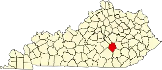
Rockcastle County
| County in de Verenigde Staten | |||
|---|---|---|---|
| |||
| Situering | |||
| Staat | Kentucky | ||
| Coördinaten | 37°21'36"NB, 84°19'12"WL | ||
| Algemeen | |||
| Oppervlakte | 823 km² | ||
| - land | 822 km² | ||
| - water | 1 km² | ||
| Inwoners (2000) |
16.582 (20 inw./km²) | ||
| Overig | |||
| Zetel | Mount Vernon | ||
| FIPS-code | 21203 | ||
| Opgericht | 1810 | ||
| Website | rockcastlecountyky | ||
| Foto's | |||

| |||
 Bevolkingspiramide Rockcastle County | |||
| Statistieken volkstelling Rockcastle County | |||
| |||
Rockcastle County is een county in de Amerikaanse staat Kentucky.
De county heeft een landoppervlakte van 822 km² en telt 16.582 inwoners (volkstelling 2000). De hoofdplaats is Mount Vernon.
Bevolkingsontwikkeling
| Jaar | Inwoners | % ± | |
|---|---|---|---|
| 1900 | 12.416 | — | |
| 1910 | 14.473 | 16,6% | |
| 1920 | 15.406 | 6,4% | |
| 1930 | 15.149 | −1,7% | |
| 1940 | 17.165 | 13,3% | |
| 1950 | 13.925 | −18,9% | |
| 1960 | 12.334 | −11,4% | |
| 1970 | 12.305 | −0,2% | |
| 1980 | 13.973 | 13,6% | |
| 1990 | 14.803 | 5,9% | |
| 2000 | 16.582 | 12,0% | |
| Bron: (en) Historical Decennial Census Population | |||