Random Island West
| Plaats in Canada | |||
|---|---|---|---|
 | |||
| Situering | |||
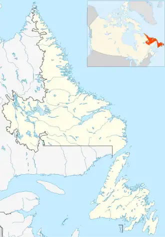
| Provincie | Newfoundland en Labrador | ||
| Censusdivisie | Divisie Nr. 7 | ||
| Regional service board | Eastern Region | ||
| Coördinaten | 48° 8′ NB, 53° 51′ WL | ||
| Algemeen | |||
| Oppervlakte | 75,14 km² | ||
| Inwoners (2021) |
405 (5,4 inw./km²) | ||
| Overig | |||
| Netnummer | 709 | ||
| Tijdzone | UTC−3:30 | ||
| |||
Random Island West is een local service district (LSD) en designated place (DPL) in de Canadese provincie Newfoundland en Labrador.[1][2]
Geografie
Random Island West bestaat uit de dorpen Aspey Brook, Elliott's Cove, Lady Cove, Random Heights, Snook's Harbour en Weybridge.[2] Het gaat om de zes meest westelijke plaatsen op Random Island, een groot eiland vlak voor de oostkust van Newfoundland.
De hoofdbaan van het local service district is provinciale route 231, de weg die Random Island verbindt met de op Newfoundland gelegen gemeente Clarenville. Van west naar oost zijn de plaatsen Random Heights, Elliot's Cove, Weybridge en Lady Cove aan deze baan gelegen, terwijl Aspey Brook en Snook's Harbour zich aan noordwaarts lopende aftakkingen ervan bevinden.
Geschiedenis
Het local service district Random Island West werd opgericht in 1996.[2][3] Het ontstond uit de samenvoeging van het reeds bestaande LSD Elliott's Cove-Snook's Harbour-Aspey Brook met de rest van het westen van Random Island.
Demografie
Random Island West kende in de jaren na zijn oprichting in 1996 een stabiele demografische situatie, met een aanzienlijke daling in de periode 2016–2021.
| Demografische ontwikkeling van Random Island West tussen 1996 en 2021 |
|---|
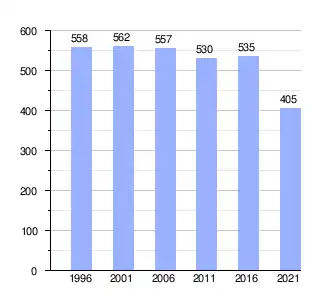 |
| Bron: Statistics Canada (1996[4], 2001–2006[5], 2011–2016[6], 2021[7]) |
Taal
In 2016 had ruim 98% van de inwoners van Random Island West het Engels als moedertaal, alle anderen waren die taal machtig.[8] Hoewel niemand het Frans als moedertaal had, waren zo'n 15 inwoners (2,6%) die andere Canadese landstaal machtig.[8]
Zie ook
- ↑ (en) Canadian Geographical Names Database, 'Random Island West', 2021. Geraadpleegd op 12 oktober 2021.
- ↑ a b c (en) Canadian Legal Information Institute, 'Newfoundland and Labrador Regulation 393/96 (Local Service District of Random Island West, NLR 393/96)', 1996.
- ↑ (en) Office of the Legislative Council of Newfoundland and Labrador, 'Table of Regulations – Municipalities Act, 1999', 2017. Geraadpleegd op 12 augustus 2023.
- ↑ (en)
 Statistics Canada, 'Population of Communities by Census Consolidated Subdivision (CCS). Newfoundland and Labrador, 1991 and 1996 Census', 1998.
- ↑ (en) Statistics Canada, 'Population of Communities by Census Consolidated Subdivision (CCS). Newfoundland and Labrador, 2006 Census', 2009.
- ↑ (en) Statistics Canada, '2016 Census Population, by 2011 Census Consolidated Subdivision (CCS) by Community, Newfoundland and Labrador', 2018.
- ↑ (en) Statistics Canada, 'Population and dwelling counts: Canada, provinces and territories, census divisions and census subdivisions (municipalities)', table: 98-10-0002-03 (geographic name: Newfoundland and Labrador), 2022.
- ↑ a b (en) Statistics Canada, 'Census Profile, 2016 Census. Random Island West, Designated place, Newfoundland and Labrador'.