Putnam County (Missouri)
| County in de Verenigde Staten | |||
|---|---|---|---|
| |||
| Situering | |||
| Staat | Missouri | ||
| Coördinaten | 40°28'48"NB, 93°1'12"WL | ||
| Algemeen | |||
| Oppervlakte | 1.346 km² | ||
| - land | 1.341 km² | ||
| - water | 5 km² | ||
| Inwoners (2000) |
5.223 (4 inw./km²) | ||
| Overig | |||
| Zetel | Unionville | ||
| FIPS-code | 29171 | ||
| Opgericht | 1845 | ||
| Website | nemr | ||
| Foto's | |||

| |||
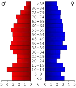 Bevolkingspiramide Putnam County | |||
| Statistieken volkstelling Putnam County | |||
| |||
Putnam County is een county in de Amerikaanse staat Missouri.
De county heeft een landoppervlakte van 1.341 km² en telt 5.223 inwoners (volkstelling 2000). De hoofdplaats is Unionville.
Bevolkingsontwikkeling
| Jaar | Inwoners | % ± | |
|---|---|---|---|
| 1900 | 16.688 | — | |
| 1910 | 14.308 | −14,3% | |
| 1920 | 13.115 | −8,3% | |
| 1930 | 11.503 | −12,3% | |
| 1940 | 11.327 | −1,5% | |
| 1950 | 9.166 | −19,1% | |
| 1960 | 6.999 | −23,6% | |
| 1970 | 5.916 | −15,5% | |
| 1980 | 6.092 | 3,0% | |
| 1990 | 5.079 | −16,6% | |
| 2000 | 5.223 | 2,8% | |
| Bron: (en) Historical Decennial Census Population | |||