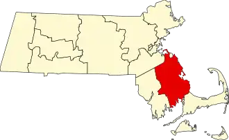
Plymouth County (Massachusetts)
| County in de Verenigde Staten | |||
|---|---|---|---|
| |||
| Situering | |||
| Staat | Massachusetts | ||
| Coördinaten | 41°58'43,961"NB, 70°49'8,234"WL | ||
| Algemeen | |||
| Oppervlakte | 2.832 km² | ||
| - land | 1.712 km² | ||
| - water | 1.120 km² | ||
| Inwoners (2000) |
472.822 (276 inw./km²) | ||
| Overig | |||
| Zetel | Brockton Plymouth | ||
| FIPS-code | 25023 | ||
| Opgericht | 1685 | ||
| Website | www | ||
| Foto's | |||
| |||
 Bevolkingspiramide Plymouth County | |||
| Statistieken volkstelling Plymouth County | |||
| |||
Plymouth County is een county in de Amerikaanse staat Massachusetts.
De county heeft een landoppervlakte van 1.712 km² en telt 472.822 inwoners (volkstelling 2000). De hoofdplaats is Brockton
Plymouth.
Bevolkingsontwikkeling
| Jaar | Inwoners | % ± | |
|---|---|---|---|
| 1900 | 113.985 | — | |
| 1910 | 144.337 | 26,6% | |
| 1920 | 156.968 | 8,8% | |
| 1930 | 162.311 | 3,4% | |
| 1940 | 168.824 | 4,0% | |
| 1950 | 189.468 | 12,2% | |
| 1960 | 248.449 | 31,1% | |
| 1970 | 333.314 | 34,2% | |
| 1980 | 405.437 | 21,6% | |
| 1990 | 435.276 | 7,4% | |
| 2000 | 472.822 | 8,6% | |
| Bron: (en) Historical Decennial Census Population | |||