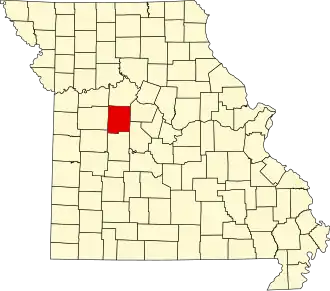
Pettis County
| County in de Verenigde Staten | |||
|---|---|---|---|
| |||
| Situering | |||
| Staat | Missouri | ||
| Coördinaten | 38°43'48"NB, 93°16'48"WL | ||
| Algemeen | |||
| Oppervlakte | 1.778 km² | ||
| - land | 1.774 km² | ||
| - water | 4 km² | ||
| Inwoners (2000) |
39.403 (22 inw./km²) | ||
| Overig | |||
| Zetel | Sedalia | ||
| FIPS-code | 29159 | ||
| Opgericht | 1833 | ||
| Website | www | ||
| Foto's | |||

| |||
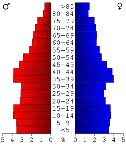 Bevolkingspiramide Pettis County | |||
| Statistieken volkstelling Pettis County | |||
| |||
Pettis County is een county in de Amerikaanse staat Missouri.
De county heeft een landoppervlakte van 1.774 km² en telt 39.403 inwoners (volkstelling 2000). De hoofdplaats is Sedalia.
Bevolkingsontwikkeling
| Jaar | Inwoners | % ± | |
|---|---|---|---|
| 1900 | 32.438 | — | |
| 1910 | 33.913 | 4,5% | |
| 1920 | 35.813 | 5,6% | |
| 1930 | 34.664 | −3,2% | |
| 1940 | 33.336 | −3,8% | |
| 1950 | 31.577 | −5,3% | |
| 1960 | 35.120 | 11,2% | |
| 1970 | 34.137 | −2,8% | |
| 1980 | 36.378 | 6,6% | |
| 1990 | 35.437 | −2,6% | |
| 2000 | 39.403 | 11,2% | |
| Bron: (en) Historical Decennial Census Population | |||