Perry County (Missouri)
| County in de Verenigde Staten | |||
|---|---|---|---|
| |||
| Situering | |||
| Staat | Missouri | ||
| Coördinaten | 37°42'36"NB, 89°49'48"WL | ||
| Algemeen | |||
| Oppervlakte | 1.254 km² | ||
| - land | 1.229 km² | ||
| - water | 25 km² | ||
| Inwoners (2000) |
18.132 (15 inw./km²) | ||
| Overig | |||
| Zetel | Perryville | ||
| FIPS-code | 29157 | ||
| Opgericht | 1820 | ||
| Website | perrycountymo | ||
| Foto's | |||

| |||
 Bevolkingspiramide Perry County | |||
| Statistieken volkstelling Perry County | |||
| |||
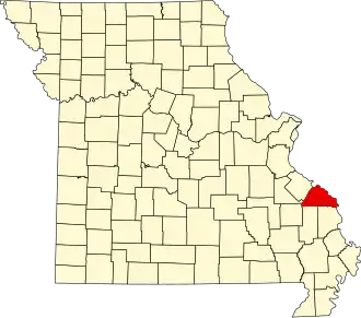
Perry County is een county in de Amerikaanse staat Missouri.
De county heeft een landoppervlakte van 1.229 km² en telt 18.132 inwoners (volkstelling 2000). De hoofdplaats is Perryville.
Bevolkingsontwikkeling
| Jaar | Inwoners | % ± | |
|---|---|---|---|
| 1900 | 15.134 | — | |
| 1910 | 14.898 | −1,6% | |
| 1920 | 14.434 | −3,1% | |
| 1930 | 13.707 | −5,0% | |
| 1940 | 15.358 | 12,0% | |
| 1950 | 14.890 | −3,0% | |
| 1960 | 14.642 | −1,7% | |
| 1970 | 14.393 | −1,7% | |
| 1980 | 16.784 | 16,6% | |
| 1990 | 16.648 | −0,8% | |
| 2000 | 18.132 | 8,9% | |
| Bron: (en) Historical Decennial Census Population | |||