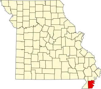
Pemiscot County
| County in de Verenigde Staten | |||
|---|---|---|---|
| |||
| Situering | |||
| Staat | Missouri | ||
| Coördinaten | 36°12'36"NB, 89°46'48"WL | ||
| Algemeen | |||
| Oppervlakte | 1.327 km² | ||
| - land | 1.277 km² | ||
| - water | 50 km² | ||
| Inwoners (2000) |
20.047 (16 inw./km²) | ||
| Overig | |||
| Zetel | Caruthersville | ||
| FIPS-code | 29155 | ||
| Opgericht | 1851 | ||
| Website | www | ||
| Foto's | |||

| |||
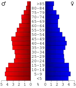 Bevolkingspiramide Pemiscot County | |||
| Statistieken volkstelling Pemiscot County | |||
| |||
Pemiscot County is een county in de Amerikaanse staat Missouri.
De county heeft een landoppervlakte van 1.277 km² en telt 20.047 inwoners (volkstelling 2000). De hoofdplaats is Caruthersville.
Bevolkingsontwikkeling
| Jaar | Inwoners | % ± | |
|---|---|---|---|
| 1900 | 12.115 | — | |
| 1910 | 19.559 | 61,4% | |
| 1920 | 26.634 | 36,2% | |
| 1930 | 37.284 | 40,0% | |
| 1940 | 46.857 | 25,7% | |
| 1950 | 45.624 | −2,6% | |
| 1960 | 38.095 | −16,5% | |
| 1970 | 26.373 | −30,8% | |
| 1980 | 24.987 | −5,3% | |
| 1990 | 21.921 | −12,3% | |
| 2000 | 20.047 | −8,5% | |
| Bron: (en) Historical Decennial Census Population | |||