Owsley County
| County in de Verenigde Staten | |||
|---|---|---|---|
| |||
| Situering | |||
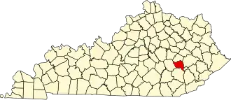
| Staat | Kentucky | ||
| Coördinaten | 37°24'36"NB, 83°41'24"WL | ||
| Algemeen | |||
| Oppervlakte | 513 km² | ||
| - land | 513 km² | ||
| - water | 0 km² | ||
| Inwoners (2000) |
4.858 (9 inw./km²) | ||
| Overig | |||
| Zetel | Booneville | ||
| FIPS-code | 21189 | ||
| Opgericht | 1843 | ||
| Website | www | ||
| Foto's | |||

| |||
 Bevolkingspiramide Owsley County | |||
| Statistieken volkstelling Owsley County | |||
| |||
Owsley County is een county in de Amerikaanse staat Kentucky.
De county heeft een landoppervlakte van 513 km² en telt 4.858 inwoners (volkstelling 2000). De hoofdplaats is Booneville.
Bevolkingsontwikkeling
| Jaar | Inwoners | % ± | |
|---|---|---|---|
| 1900 | 6.874 | — | |
| 1910 | 7.979 | 16,1% | |
| 1920 | 7.820 | −2,0% | |
| 1930 | 7.223 | −7,6% | |
| 1940 | 8.957 | 24,0% | |
| 1950 | 7.324 | −18,2% | |
| 1960 | 5.369 | −26,7% | |
| 1970 | 5.023 | −6,4% | |
| 1980 | 5.709 | 13,7% | |
| 1990 | 5.036 | −11,8% | |
| 2000 | 4.858 | −3,5% | |
| Bron: (en) Historical Decennial Census Population | |||