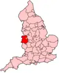
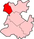
Oswestry (district)
| Civil parish in Engeland | |||
|---|---|---|---|
| |||
| Situering | |||
| Land | Engeland | ||
| County | Shropshire | ||
| Regio | West Midlands | ||
| Coördinaten | 52°51'40"NB, 3°3'18"WL | ||
| Algemeen | |||
| Oppervlakte | 8,8202 km² | ||
| Inwoners (2011) |
17.105 (1939 inw./km²) | ||
| ONS-code | E04011336 | ||
| Website | www | ||
| |||
Oswestry was tot 2009 een Engels district in het graafschap Shropshire en telde 37.308 inwoners. De oppervlakte bedraagt 256,1 km².
Van de bevolking was 17,7% ouder dan 65 jaar. De werkloosheid bedraagt 3,2% van de beroepsbevolking (cijfers volkstelling 2001).
Plaatsen in district Oswestry
- Gobowen
- Oswestry
- Pant
- Ruyton XI Towns
- St Martin's
- Trefonen
- Whittington
Bronnen, noten en/of referenties