Ontonagon County
| County in de Verenigde Staten | |||
|---|---|---|---|
| |||
| Situering | |||
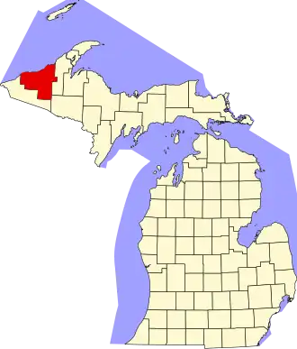
| Staat | Michigan | ||
| Coördinaten | 46°58'48"NB, 89°16'12"WL | ||
| Algemeen | |||
| Oppervlakte | 9.690 km² | ||
| - land | 3.397 km² | ||
| - water | 6.293 km² | ||
| Inwoners (2000) |
7.818 (2 inw./km²) | ||
| Overig | |||
| Zetel | Ontonagon | ||
| FIPS-code | 26131 | ||
| Opgericht | 1843 | ||
| Website | ontonagoncounty | ||
| Foto's | |||

| |||
 Bevolkingspiramide Ontonagon County | |||
| Statistieken volkstelling Ontonagon County | |||
| |||
Ontonagon County is een county in de Amerikaanse staat Michigan.
De county heeft een landoppervlakte van 3.397 km² en telt 7.818 inwoners (volkstelling 2000). De hoofdplaats is Ontonagon.
Bevolkingsontwikkeling
| Jaar | Inwoners | % ± | |
|---|---|---|---|
| 1900 | 6.197 | — | |
| 1910 | 8.650 | 39,6% | |
| 1920 | 12.428 | 43,7% | |
| 1930 | 11.114 | −10,6% | |
| 1940 | 11.359 | 2,2% | |
| 1950 | 10.282 | −9,5% | |
| 1960 | 10.584 | 2,9% | |
| 1970 | 10.548 | −0,3% | |
| 1980 | 9.861 | −6,5% | |
| 1990 | 8.854 | −10,2% | |
| 2000 | 7.818 | −11,7% | |
| Bron: (en) Historical Decennial Census Population | |||