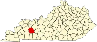
Muhlenberg County
| County in de Verenigde Staten | |||
|---|---|---|---|
| |||
| Situering | |||
| Staat | Kentucky | ||
| Coördinaten | 37°12'36"NB, 87°9'0"WL | ||
| Algemeen | |||
| Oppervlakte | 1.242 km² | ||
| - land | 1.230 km² | ||
| - water | 12 km² | ||
| Inwoners (2000) |
31.839 (26 inw./km²) | ||
| Overig | |||
| Zetel | Greenville | ||
| FIPS-code | 21177 | ||
| Opgericht | 1798 | ||
| Website | muhlenbergcounty | ||
| Foto's | |||

| |||
 Bevolkingspiramide Muhlenberg County | |||
| Statistieken volkstelling Muhlenberg County | |||
| |||
Muhlenberg County is een county in de Amerikaanse staat Kentucky.
De county heeft een landoppervlakte van 1.230 km² en telt 31.839 inwoners (volkstelling 2000). De hoofdplaats is Greenville en de dichtstbevolkte stad is Central City.
Bevolkingsontwikkeling
| Jaar | Inwoners | % ± | |
|---|---|---|---|
| 1900 | 20.741 | — | |
| 1910 | 28.598 | 37,9% | |
| 1920 | 33.353 | 16,6% | |
| 1930 | 37.784 | 13,3% | |
| 1940 | 37.554 | −0,6% | |
| 1950 | 32.501 | −13,5% | |
| 1960 | 27.791 | −14,5% | |
| 1970 | 27.537 | −0,9% | |
| 1980 | 32.238 | 17,1% | |
| 1990 | 31.318 | −2,9% | |
| 2000 | 31.839 | 1,7% | |
| Bron: (en) Historical Decennial Census Population | |||