Montefortino
| Gemeente in Italië | |||
|---|---|---|---|
 | |||
| Situering | |||
| Regio | Marche (MAR) | ||
| Provincie | Fermo (FM) | ||
| Coördinaten | 42° 57′ NB, 13° 21′ OL | ||
| Algemeen | |||
| Oppervlakte | 78,5 km² | ||
| Inwoners (1 januari 2023) |
1.047[1] (17 inw./km²) | ||
| Overig | |||
| Postcode | 63047 | ||
| Netnummer | 0736 | ||
| Beschermheilige | Michaël | ||
| ISTAT-code | 109015 | ||
| Website | http://www.montefortino.com | ||
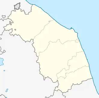
| Detailkaart | |||
.svg.png)
| |||
| Locatie van Montefortino in Fermo (FM) | |||
 | |||
| Foto's | |||
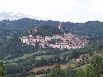
| |||
| Montefortino | |||
| |||
Montefortino is een gemeente in de Italiaanse provincie Fermo (regio Marche) en telt 1312 inwoners (31-12-2004). De oppervlakte bedraagt 78,5 km², de bevolkingsdichtheid is 17 inwoners per km².
Demografie
Montefortino telt ongeveer 554 huishoudens. Het aantal inwoners daalde in de periode 1991-2001 met 7,7% volgens cijfers uit de tienjaarlijkse volkstellingen van ISTAT.
| Jaar | Inwoneraantal |
|---|---|
| 1991 | 1411 |
| 2001 | 1303 |
Geografie
Montefortino grenst aan de volgende gemeenten: Amandola, Bolognola (MC), Castelsantangelo sul Nera (MC), Comunanza, Montemonaco, Sarnano (MC), Ussita (MC), Visso (MC).
Bronnen, noten en/of referenties
Zie de categorie Montefortino van Wikimedia Commons voor mediabestanden over dit onderwerp.