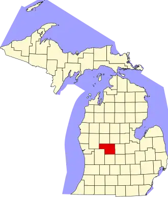
Montcalm County
| County in de Verenigde Staten | |||
|---|---|---|---|
| |||
| Situering | |||
| Staat | Michigan | ||
| Coördinaten | 43°18'36"NB, 85°9'0"WL | ||
| Algemeen | |||
| Oppervlakte | 1.868 km² | ||
| - land | 1.834 km² | ||
| - water | 34 km² | ||
| Inwoners (2000) |
61.266 (33 inw./km²) | ||
| Overig | |||
| Zetel | Stanton | ||
| FIPS-code | 26117 | ||
| Opgericht | 1831 | ||
| Website | www | ||
| Foto's | |||
| |||
 Bevolkingspiramide Montcalm County | |||
| Statistieken volkstelling Montcalm County | |||
| |||
Montcalm County is een county in de Amerikaanse staat Michigan.
De county heeft een landoppervlakte van 1.834 km² en telt 61.266 inwoners (volkstelling 2000). De hoofdplaats is Stanton.
Bevolkingsontwikkeling
| Jaar | Inwoners | % ± | |
|---|---|---|---|
| 1900 | 32.754 | — | |
| 1910 | 32.069 | −2,1% | |
| 1920 | 30.441 | −5,1% | |
| 1930 | 27.471 | −9,8% | |
| 1940 | 28.581 | 4,0% | |
| 1950 | 31.013 | 8,5% | |
| 1960 | 35.795 | 15,4% | |
| 1970 | 39.660 | 10,8% | |
| 1980 | 47.555 | 19,9% | |
| 1990 | 53.059 | 11,6% | |
| 2000 | 61.266 | 15,5% | |
| Bron: (en) Historical Decennial Census Population | |||