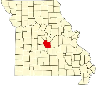
Miller County (Missouri)
| County in de Verenigde Staten | |||
|---|---|---|---|
| |||
| Situering | |||
| Staat | Missouri | ||
| Coördinaten | 38°13'12"NB, 92°25'48"WL | ||
| Algemeen | |||
| Oppervlakte | 1.554 km² | ||
| - land | 1.534 km² | ||
| - water | 20 km² | ||
| Inwoners (2000) |
23.564 (15 inw./km²) | ||
| Overig | |||
| Zetel | Tuscumbia | ||
| FIPS-code | 29131 | ||
| Opgericht | 1837 | ||
| Website | www | ||
| Foto's | |||

| |||
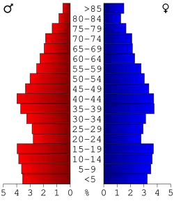 Bevolkingspiramide Miller County | |||
| Statistieken volkstelling Miller County | |||
| |||
Miller County is een county in de Amerikaanse staat Missouri.
De county heeft een landoppervlakte van 1.534 km² en telt 23.564 inwoners (volkstelling 2000). De hoofdplaats is Tuscumbia.
Bevolkingsontwikkeling
| Jaar | Inwoners | % ± | |
|---|---|---|---|
| 1900 | 15.187 | — | |
| 1910 | 16.717 | 10,1% | |
| 1920 | 15.567 | −6,9% | |
| 1930 | 16.728 | 7,5% | |
| 1940 | 14.798 | −11,5% | |
| 1950 | 13.734 | −7,2% | |
| 1960 | 13.800 | 0,5% | |
| 1970 | 15.026 | 8,9% | |
| 1980 | 18.532 | 23,3% | |
| 1990 | 20.700 | 11,7% | |
| 2000 | 23.564 | 13,8% | |
| Bron: (en) Historical Decennial Census Population | |||