Middlesbrough (district)
| Unitaire autoriteit in Engeland | |||
|---|---|---|---|
 | |||
| |||
| Situering | |||
| Land | Engeland | ||
| Regio | North East England | ||
| Coördinaten | 54°34'23"NB, 1°14'17"WL | ||
| Algemeen | |||
| Oppervlakte | 53,8888[1] km² | ||
| Inwoners (2018[2]) |
140.545 (2608 inw./km²) | ||
| Hoofdplaats ONS-code |
Middlesbrough E06000002 | ||
| Website | www | ||
| Detailkaart | |||
.svg.png)
| |||
| Foto's | |||
.jpg)
| |||
| Gemeentehuis van Middlesbrough | |||
| |||
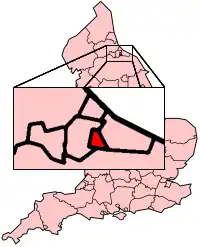
Middlesbrough is een unitary authority, een borough en een district in het ceremoniële graafschap North Yorkshire, in de regio North East England en telt 141.000 inwoners. Hoofdplaats is Middlesbrough
Civil parishes in district Middlesbrough
- Nunthorpe
- Stainton and Thornton
Council wards in district Middlesbrough
De borough heeft 23 council wards, waaronder
- Coulby Newham
- Hemlington
- Marton
- Ormesby
- Stainton & Thornton
Bronnen, noten en/of referenties
- ↑ Office for National Statistics → Download → SAM_for_Administrative_Areas_(2018).zip → SAM_LAD_DEC_2018_UK.xlsx. Gearchiveerd op 2 oktober 2023.
- ↑ https://www.ons.gov.uk/file?uri=/peoplepopulationandcommunity/populationandmigration/populationestimates/datasets/populationestimatesforukenglandandwalesscotlandandnorthernireland/mid20182019laboundaries/ukmidyearestimates20182019ladcodes.xls Schatting Office for National Statistics: knop MYE5 → kolom Estimated Population mid-2018]. Gearchiveerd op 8 oktober 2024.