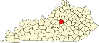
Mercer County (Kentucky)
| County in de Verenigde Staten | |||
|---|---|---|---|
| |||
| Situering | |||
| Staat | Kentucky | ||
| Coördinaten | 37°48'0"NB, 84°52'48"WL | ||
| Algemeen | |||
| Oppervlakte | 656 km² | ||
| - land | 650 km² | ||
| - water | 6 km² | ||
| Inwoners (2000) |
20.817 (32 inw./km²) | ||
| Overig | |||
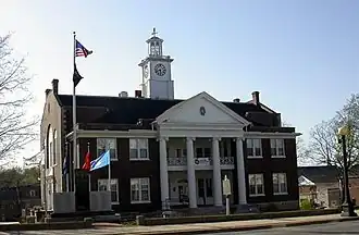
| Zetel | Harrodsburg | ||
| FIPS-code | 21167 | ||
| Opgericht | 1785 | ||
| Website | www | ||
| Foto's | |||
| |||
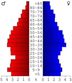 Bevolkingspiramide Mercer County | |||
| Statistieken volkstelling Mercer County | |||
| |||
Mercer County is een county in de Amerikaanse staat Kentucky.
De county heeft een landoppervlakte van 650 km² en telt 20.817 inwoners (volkstelling 2000). De hoofdplaats is Harrodsburg.
Bevolkingsontwikkeling
| Jaar | Inwoners | % ± | |
|---|---|---|---|
| 1900 | 14.426 | — | |
| 1910 | 14.063 | −2,5% | |
| 1920 | 14.795 | 5,2% | |
| 1930 | 14.471 | −2,2% | |
| 1940 | 14.629 | 1,1% | |
| 1950 | 14.643 | 0,1% | |
| 1960 | 14.596 | −0,3% | |
| 1970 | 15.960 | 9,3% | |
| 1980 | 19.011 | 19,1% | |
| 1990 | 19.148 | 0,7% | |
| 2000 | 20.817 | 8,7% | |
| Bron: (en) Historical Decennial Census Population | |||