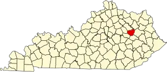
Menifee County
| County in de Verenigde Staten | |||
|---|---|---|---|
| |||
| Situering | |||
| Staat | Kentucky | ||
| Coördinaten | 37°57'NB, 83°36'WL | ||
| Algemeen | |||
| Oppervlakte | 534 km² | ||
| - land | 528 km² | ||
| - water | 6 km² | ||
| Inwoners (2000) |
6.556 (12 inw./km²) | ||
| Overig | |||
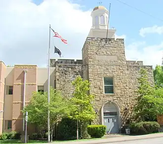
| Zetel | Frenchburg | ||
| FIPS-code | 21165 | ||
| Opgericht | 1869 | ||
| Website | www | ||
| Foto's | |||
| |||
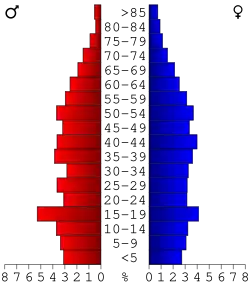 Bevolkingspiramide Menifee County | |||
| Statistieken volkstelling Menifee County | |||
| |||
Menifee County is een county in de Amerikaanse staat Kentucky.
De county heeft een landoppervlakte van 528 km² en telt 6.556 inwoners (volkstelling 2000). De hoofdplaats is Frenchburg.
Bevolkingsontwikkeling
| Jaar | Inwoners | % ± | |
|---|---|---|---|
| 1900 | 6.818 | — | |
| 1910 | 6.153 | −9,8% | |
| 1920 | 5.779 | −6,1% | |
| 1930 | 4.958 | −14,2% | |
| 1940 | 5.691 | 14,8% | |
| 1950 | 4.798 | −15,7% | |
| 1960 | 4.276 | −10,9% | |
| 1970 | 4.050 | −5,3% | |
| 1980 | 5.117 | 26,3% | |
| 1990 | 5.092 | −0,5% | |
| 2000 | 6.556 | 28,8% | |
| Bron: (en) Historical Decennial Census Population | |||