McPherson County (Kansas)
| County in de Verenigde Staten | |||
|---|---|---|---|
| |||
| Situering | |||
| Staat | Kansas | ||
| Coördinaten | 38°24'NB, 97°42'WL | ||
| Algemeen | |||
| Oppervlakte | 2.334 km² | ||
| - land | 2.330 km² | ||
| - water | 4 km² | ||
| Inwoners (2000) |
29.554 (13 inw./km²) | ||
| Overig | |||
| Zetel | McPherson | ||
| FIPS-code | 20113 | ||
| Opgericht | 1867 | ||
| Website | mcphersoncountyks | ||
| Detailkaart | |||
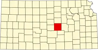
| |||
| Overzichtskaart van McPherson County | |||
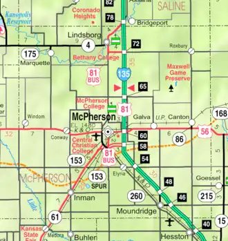
| Foto's | |||
.jpg)
| |||
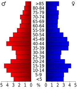 Bevolkingspiramide McPherson County | |||
| Statistieken volkstelling McPherson County | |||
| |||
McPherson County is een county in de Amerikaanse staat Kansas.
De county heeft een landoppervlakte van 2.330 km² en telt 29.554 inwoners (volkstelling 2000). De hoofdplaats is McPherson.
Bevolkingsontwikkeling
| Jaar | Inwoners | % ± | |
|---|---|---|---|
| 1900 | 21.421 | — | |
| 1910 | 21.521 | 0,5% | |
| 1920 | 21.845 | 1,5% | |
| 1930 | 23.588 | 8,0% | |
| 1940 | 24.152 | 2,4% | |
| 1950 | 23.670 | −2,0% | |
| 1960 | 24.285 | 2,6% | |
| 1970 | 24.778 | 2,0% | |
| 1980 | 26.855 | 8,4% | |
| 1990 | 27.268 | 1,5% | |
| 2000 | 29.554 | 8,4% | |
| Bron: (en) Historical Decennial Census Population | |||
Zie de categorie McPherson County, Kansas van Wikimedia Commons voor mediabestanden over dit onderwerp.