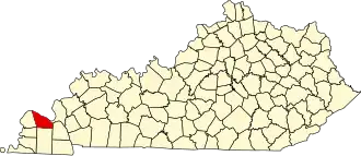
McCracken County
| County in de Verenigde Staten | |||
|---|---|---|---|
| |||
| Situering | |||
| Staat | Kentucky | ||
| Coördinaten | 37°3'36"NB, 88°43'12"WL | ||
| Algemeen | |||
| Oppervlakte | 694 km² | ||
| - land | 650 km² | ||
| - water | 44 km² | ||
| Inwoners (2000) |
65.514 (101 inw./km²) | ||
| Overig | |||
| Zetel | Paducah | ||
| FIPS-code | 21145 | ||
| Opgericht | 1824 | ||
| Website | mccrackencounty | ||
| Foto's | |||

| |||
 Bevolkingspiramide McCracken County | |||
| Statistieken volkstelling McCracken County | |||
| |||
McCracken County is een county in de Amerikaanse staat Kentucky.
De county heeft een landoppervlakte van 650 km² en telt 65.514 inwoners (volkstelling 2000). De hoofdplaats is Paducah.
Bevolkingsontwikkeling
| Jaar | Inwoners | % ± | |
|---|---|---|---|
| 1900 | 28.733 | — | |
| 1910 | 35.064 | 22,0% | |
| 1920 | 37.246 | 6,2% | |
| 1930 | 46.271 | 24,2% | |
| 1940 | 48.534 | 4,9% | |
| 1950 | 49.137 | 1,2% | |
| 1960 | 57.306 | 16,6% | |
| 1970 | 58.281 | 1,7% | |
| 1980 | 61.310 | 5,2% | |
| 1990 | 62.879 | 2,6% | |
| 2000 | 65.514 | 4,2% | |
| Bron: (en) Historical Decennial Census Population | |||