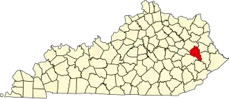
Magoffin County
| County in de Verenigde Staten | |||
|---|---|---|---|
| |||
| Situering | |||
| Staat | Kentucky | ||
| Coördinaten | 37°42'0"NB, 83°3'36"WL | ||
| Algemeen | |||
| Oppervlakte | 801 km² | ||
| - land | 801 km² | ||
| - water | 0 km² | ||
| Inwoners (2000) |
13.332 (17 inw./km²) | ||
| Overig | |||
| Zetel | Salyersville | ||
| FIPS-code | 21153 | ||
| Opgericht | 1860 | ||
| Website | magoffincounty | ||
| Foto's | |||

| |||
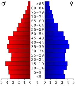 Bevolkingspiramide Magoffin County | |||
| Statistieken volkstelling Magoffin County | |||
| |||
Magoffin County is een county in de Amerikaanse staat Kentucky.
De county heeft een landoppervlakte van 801 km² en telt 13.332 inwoners (volkstelling 2000). De hoofdplaats is Salyersville.
Bevolkingsontwikkeling
| Jaar | Inwoners | % ± | |
|---|---|---|---|
| 1900 | 12.006 | — | |
| 1910 | 13.654 | 13,7% | |
| 1920 | 13.859 | 1,5% | |
| 1930 | 15.719 | 13,4% | |
| 1940 | 17.490 | 11,3% | |
| 1950 | 13.839 | −20,9% | |
| 1960 | 11.156 | −19,4% | |
| 1970 | 10.443 | −6,4% | |
| 1980 | 13.515 | 29,4% | |
| 1990 | 13.077 | −3,2% | |
| 2000 | 13.332 | 1,9% | |
| Bron: (en) Historical Decennial Census Population | |||