Mackinac County
| County in de Verenigde Staten | |||
|---|---|---|---|
| |||
| Situering | |||
| Staat | Michigan | ||
| Coördinaten | 46°0'36"NB, 85°0'36"WL | ||
| Algemeen | |||
| Oppervlakte | 5.440 km² | ||
| - land | 2.646 km² | ||
| - water | 2.794 km² | ||
| Inwoners (2000) |
11.943 (5 inw./km²) | ||
| Overig | |||
| Zetel | St. Ignace | ||
| FIPS-code | 26097 | ||
| Opgericht | 1818 | ||
| Website | www | ||
| Foto's | |||
_-_panoramio.jpg)
| |||
 Bevolkingspiramide Mackinac County | |||
| Statistieken volkstelling Mackinac County | |||
| |||
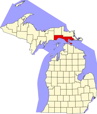
Mackinac County is een county in de Amerikaanse staat Michigan.
De county heeft een landoppervlakte van 2.646 km² en telt 11.943 inwoners (volkstelling 2000). De hoofdplaats is St.Ignace.
Bevolkingsontwikkeling
| Jaar | Inwoners | % ± | |
|---|---|---|---|
| 1900 | 7.703 | — | |
| 1910 | 9.249 | 20,1% | |
| 1920 | 8.026 | −13,2% | |
| 1930 | 8.783 | 9,4% | |
| 1940 | 9.438 | 7,5% | |
| 1950 | 9.287 | −1,6% | |
| 1960 | 10.853 | 16,9% | |
| 1970 | 9.660 | −11,0% | |
| 1980 | 10.178 | 5,4% | |
| 1990 | 10.674 | 4,9% | |
| 2000 | 11.943 | 11,9% | |
| Bron: (en) Historical Decennial Census Population | |||
Zie ook