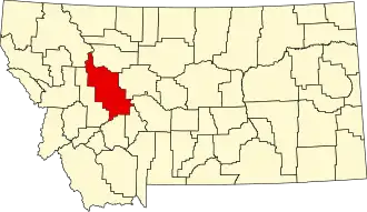
Lewis and Clark County
| County in de Verenigde Staten | |||
|---|---|---|---|
| |||
| Situering | |||
| Staat | Montana | ||
| Coördinaten | 47°6'36"NB, 112°22'48"WL | ||
| Algemeen | |||
| Oppervlakte | 9.059 km² | ||
| - land | 8.964 km² | ||
| - water | 95 km² | ||
| Inwoners (2000) |
55.716 (6 inw./km²) | ||
| Overig | |||
| Zetel | Helena | ||
| FIPS-code | 30049 | ||
| Opgericht | 1864 | ||
| Website | www | ||
| Foto's | |||

| |||
 Bevolkingspiramide Lewis and Clark County | |||
| Statistieken volkstelling Lewis and Clark County | |||
| |||
Lewis and Clark County is een county in de Amerikaanse staat Montana.
De county heeft een landoppervlakte van 8.964 km² en telt 55.716 inwoners (volkstelling 2000). De hoofdplaats is Helena.
Bevolkingsontwikkeling
| Jaar | Inwoners | % ± | |
|---|---|---|---|
| 1900 | 19.171 | — | |
| 1910 | 21.853 | 14,0% | |
| 1920 | 18.660 | −14,6% | |
| 1930 | 18.224 | −2,3% | |
| 1940 | 22.131 | 21,4% | |
| 1950 | 24.540 | 10,9% | |
| 1960 | 28.006 | 14,1% | |
| 1970 | 33.281 | 18,8% | |
| 1980 | 43.039 | 29,3% | |
| 1990 | 47.495 | 10,4% | |
| 2000 | 55.716 | 17,3% | |
| Bron: (en) Historical Decennial Census Population | |||