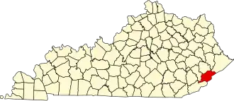
Letcher County
| County in de Verenigde Staten | |||
|---|---|---|---|
| |||
| Situering | |||
| Staat | Kentucky | ||
| Coördinaten | 37°7'12"NB, 82°51'0"WL | ||
| Algemeen | |||
| Oppervlakte | 878 km² | ||
| - land | 878 km² | ||
| - water | 0 km² | ||
| Inwoners (2000) |
25.277 (29 inw./km²) | ||
| Overig | |||
| Zetel | Whitesburg | ||
| FIPS-code | 21133 | ||
| Opgericht | 1842 | ||
| Website | www | ||
| Foto's | |||

| |||
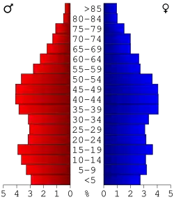 Bevolkingspiramide Letcher County | |||
| Statistieken volkstelling Letcher County | |||
| |||
Letcher County is een county in de Amerikaanse staat Kentucky.
De county heeft een landoppervlakte van 878 km² en telt 25.277 inwoners (volkstelling 2000). De hoofdplaats is Whitesburg.
Bevolkingsontwikkeling
| Jaar | Inwoners | % ± | |
|---|---|---|---|
| 1900 | 9.172 | — | |
| 1910 | 10.623 | 15,8% | |
| 1920 | 24.467 | 130,3% | |
| 1930 | 35.702 | 45,9% | |
| 1940 | 40.592 | 13,7% | |
| 1950 | 39.522 | −2,6% | |
| 1960 | 30.102 | −23,8% | |
| 1970 | 23.165 | −23,0% | |
| 1980 | 30.687 | 32,5% | |
| 1990 | 27.000 | −12,0% | |
| 2000 | 25.277 | −6,4% | |
| Bron: (en) Historical Decennial Census Population | |||