Lapugnoy
| Gemeente in Frankrijk | |||
|---|---|---|---|
 | |||
 | |||
| Situering | |||
| Regio | Hauts-de-France | ||
| Departement | Pas-de-Calais (62) | ||
| Arrondissement | Béthune | ||
| Kanton | Béthune | ||
| Coördinaten | 50° 31′ NB, 2° 32′ OL | ||
| Algemeen | |||
| Oppervlakte | 8,61 km² | ||
| Inwoners (1 januari 2022) |
3.500[1] (407 inw./km²) | ||
| Hoogte | 24 - 93 m | ||
| Overig | |||
| Postcode | 62122 | ||
| INSEE-code | 62489 | ||
| Website | Officiële website | ||
| Detailkaart | |||
 | |||
| Foto's | |||
.JPG)
| |||
| Gemeentehuis | |||
| |||
Lapugnoy is een gemeente in het Franse departement Pas-de-Calais (regio Hauts-de-France). De plaats maakt deel uit van het arrondissement Béthune. Lapugnoy telde op 1 januari 2022 3.500[1] inwoners.
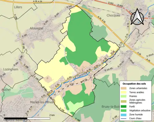
Geografie
De oppervlakte van Lapugnoy bedroeg op 1 januari 2022 8,61 vierkante kilometer; de bevolkingsdichtheid was toen 406,5 inwoners per km².
Demografie
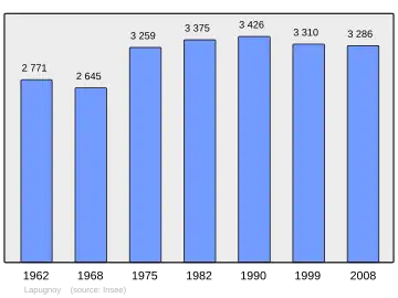
Onderstaande figuur toont het verloop van het inwonertal (bron: INSEE-tellingen).
Externe links
- (fr) Statistische informatie op de website van het Franse bureau voor statistiek INSEE
Zie de categorie Lapugnoy van Wikimedia Commons voor mediabestanden over dit onderwerp.