Lafayette County (Arkansas)
| County in de Verenigde Staten | |||
|---|---|---|---|
| |||
| Situering | |||
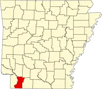
| Staat | Arkansas | ||
| Coördinaten | 33°15'51"NB, 93°35'34"WL | ||
| Algemeen | |||
| Oppervlakte | 1.412 km² | ||
| - land | 1.364 km² | ||
| - water | 48 km² | ||
| Inwoners (2000) |
8.559 (6 inw./km²) | ||
| Overig | |||
| Zetel | Lewisville | ||
| FIPS-code | 05073 | ||
| Opgericht | 1827 | ||
| Website | www | ||
| Foto's | |||

| |||
 Bevolkingspiramide Lafayette County | |||
| Statistieken volkstelling Lafayette County | |||
| |||
Lafayette County is een county in de Amerikaanse staat Arkansas. De county heeft een landoppervlakte van 1.364 km² en telt 8.559 inwoners (volkstelling 2000). De hoofdplaats is Lewisville.
De county is vernoemd naar Markies De la Fayette, een Franse aristocraat die in de Amerikaanse Onafhankelijkheidsoorlog meestreed.[1]
Bevolkingsontwikkeling
| Jaar | Inwoners | % ± | |
|---|---|---|---|
| 1900 | 10.594 | — | |
| 1910 | 13.741 | 29,7% | |
| 1920 | 15.522 | 13,0% | |
| 1930 | 16.934 | 9,1% | |
| 1940 | 16.851 | −0,5% | |
| 1950 | 13.203 | −21,6% | |
| 1960 | 11.030 | −16,5% | |
| 1970 | 10.018 | −9,2% | |
| 1980 | 10.213 | 1,9% | |
| 1990 | 9.643 | −5,6% | |
| 2000 | 8.559 | −11,2% | |
| Bron: (en) Historical Decennial Census Population | |||
Bronnen, noten en/of referenties
- ↑ (en) Henry Gannett, The Origin of Certain Place Names in the United States, Washington Government Printing Office (1905). Gearchiveerd op 7 september 2023.