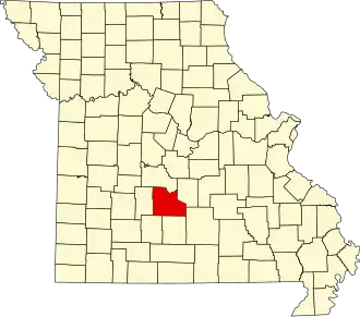
Laclede County
| County in de Verenigde Staten | |||
|---|---|---|---|
| |||
| Situering | |||
| Staat | Missouri | ||
| Coördinaten | 37°39'36"NB, 92°35'24"WL | ||
| Algemeen | |||
| Oppervlakte | 1.990 km² | ||
| - land | 1.984 km² | ||
| - water | 6 km² | ||
| Inwoners (2000) |
32.513 (16 inw./km²) | ||
| Overig | |||
| Zetel | Lebanon | ||
| FIPS-code | 29105 | ||
| Opgericht | 1849 | ||
| Website | lacledecountymissouri | ||
| Foto's | |||
| |||
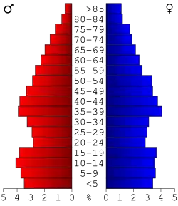 Bevolkingspiramide Laclede County | |||
| Statistieken volkstelling Laclede County | |||
| |||
Laclede County is een county in de Amerikaanse staat Missouri.
De county heeft een landoppervlakte van 1.984 km² en telt 32.513 inwoners (volkstelling 2000). De hoofdplaats is Lebanon.
Bevolkingsontwikkeling
| Jaar | Inwoners | % ± | |
|---|---|---|---|
| 1900 | 16.523 | — | |
| 1910 | 17.363 | 5,1% | |
| 1920 | 16.857 | −2,9% | |
| 1930 | 16.320 | −3,2% | |
| 1940 | 18.718 | 14,7% | |
| 1950 | 19.010 | 1,6% | |
| 1960 | 18.991 | −0,1% | |
| 1970 | 19.944 | 5,0% | |
| 1980 | 24.323 | 22,0% | |
| 1990 | 27.158 | 11,7% | |
| 2000 | 32.513 | 19,7% | |
| Bron: (en) Historical Decennial Census Population | |||