Kirklees
| Metropolitaans district in Engeland | |||
|---|---|---|---|
 | |||
.svg.png)
| |||
| Situering | |||
| Land | Engeland | ||
| County | West Yorkshire | ||
| Regio | Yorkshire and the Humber | ||
| Coördinaten | 53°35'35"NB, 1°48'4"WL | ||
| Algemeen | |||
| Oppervlakte | 408,5516[1] km² | ||
| Inwoners (2018[2]) |
438.727 (1074 inw./km²) | ||
| ONS-code | E08000034 | ||
| Website | www | ||
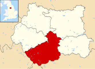
| Detailkaart | |||
| |||
| |||
Kirklees is een Engels district in het stedelijk graafschap (metropolitan county) West Yorkshire en telt 437.145 inwoners. De oppervlakte bedraagt 409 km².
Van de bevolking is 14,6% ouder dan 65 jaar. De werkloosheid bedraagt 3,4% van de beroepsbevolking (cijfers volkstelling 2001).
Plaatsen in district Kirklees
Civil parishes in district Kirklees
Bronnen, noten en/of referenties
- ↑ Office for National Statistics → Download → SAM_for_Administrative_Areas_(2018).zip → SAM_LAD_DEC_2018_UK.xlsx. Gearchiveerd op 15 augustus 2023.
- ↑ https://www.ons.gov.uk/file?uri=/peoplepopulationandcommunity/populationandmigration/populationestimates/datasets/populationestimatesforukenglandandwalesscotlandandnorthernireland/mid20182019laboundaries/ukmidyearestimates20182019ladcodes.xls Schatting Office for National Statistics: knop MYE5 → kolom Estimated Population mid-2018]