Kent County (Rhode Island)
| County in de Verenigde Staten | |||
|---|---|---|---|

| |||
| Situering | |||
| Staat | Rhode Island | ||
| Coördinaten | 41°42'14,846"NB, 71°28'46,308"WL | ||
| Algemeen | |||
| Oppervlakte | 487 km² | ||
| - land | 441 km² | ||
| - water | 46 km² | ||
| Inwoners (2000) |
167.090 (379 inw./km²) | ||
| Overig | |||
| Zetel | East Greenwich | ||
| FIPS-code | 44003 | ||
| Opgericht | 1750 | ||
| Detailkaart | |||
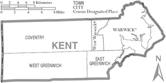
| |||
| Overzichtskaart van Kent County | |||
| Foto's | |||
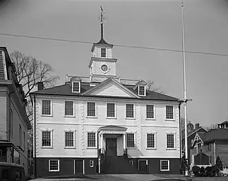
| |||
 Bevolkingspiramide Kent County | |||
| Statistieken volkstelling Kent County | |||
| |||
Kent County is een van de 5 county's in de Amerikaanse staat Rhode Island.
De county heeft een landoppervlakte van 441 km² en telt 167.090 inwoners (volkstelling 2000). De hoofdplaats is East Greenwich.
Bevolkingsontwikkeling
| Jaar | Inwoners | % ± | |
|---|---|---|---|
| 1900 | 29.976 | — | |
| 1910 | 36.378 | 21,4% | |
| 1920 | 38.269 | 5,2% | |
| 1930 | 51.390 | 34,3% | |
| 1940 | 58.311 | 13,5% | |
| 1950 | 77.763 | 33,4% | |
| 1960 | 112.619 | 44,8% | |
| 1970 | 142.382 | 26,4% | |
| 1980 | 154.163 | 8,3% | |
| 1990 | 161.135 | 4,5% | |
| 2000 | 167.090 | 3,7% | |
| Bron: (en) Historical Decennial Census Population | |||