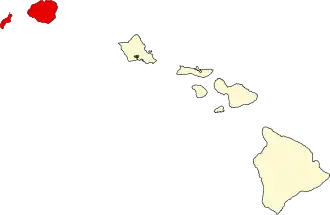
Kauai County
| County in de Verenigde Staten | |||
|---|---|---|---|
| |||
| Situering | |||
| Staat | Hawaï | ||
| Coördinaten | 22°4'0"NB, 159°39'0"WL | ||
| Algemeen | |||
| Oppervlakte | 3.280 km² | ||
| - land | 1.612 km² | ||
| - water | 1.668 km² | ||
| Inwoners (2000) |
58.463 (36 inw./km²) | ||
| Overig | |||
| Zetel | Lihue | ||
| FIPS-code | 15007 | ||
| Opgericht | 1905 | ||
| Website | www | ||
| Foto's | |||

| |||
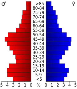 Bevolkingspiramide Kauai County | |||
| Statistieken volkstelling Kauai County | |||
| |||
Kauai County is een county in de Amerikaanse staat Hawaï. Het omvat de eilanden Kauai, Niihau, Lehua, and Kaula.
De county heeft een landoppervlakte van 1.612 km² en telt 58.463 inwoners (volkstelling 2000). De hoofdplaats is Lihue.
Bevolkingsontwikkeling
| Jaar | Inwoners | % ± | |
|---|---|---|---|
| 1900 | 20.734 | — | |
| 1910 | 23.952 | 15,5% | |
| 1920 | 29.438 | 22,9% | |
| 1930 | 35.942 | 22,1% | |
| 1940 | 35.818 | −0,3% | |
| 1950 | 29.905 | −16,5% | |
| 1960 | 28.176 | −5,8% | |
| 1970 | 29.761 | 5,6% | |
| 1980 | 39.082 | 31,3% | |
| 1990 | 51.177 | 30,9% | |
| 2000 | 58.463 | 14,2% | |
| Bron: (en) Historical Decennial Census Population | |||
Externe link