Johnson County (Kentucky)
| County in de Verenigde Staten | |||
|---|---|---|---|
| |||
| Situering | |||
| Staat | Kentucky | ||
| Coördinaten | 37°50'24"NB, 82°49'48"WL | ||
| Algemeen | |||
| Oppervlakte | 683 km² | ||
| - land | 677 km² | ||
| - water | 6 km² | ||
| Inwoners (2000) |
23.445 (35 inw./km²) | ||
| Overig | |||
| Zetel | Paintsville | ||
| FIPS-code | 21115 | ||
| Opgericht | 1843 | ||
| Website | www | ||
| Foto's | |||

| |||
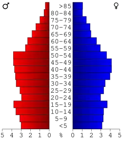 Bevolkingspiramide Johnson County | |||
| Statistieken volkstelling Johnson County | |||
| |||
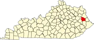
Johnson County is een county in de Amerikaanse staat Kentucky.
De county heeft een landoppervlakte van 677 km² en telt 23.445 inwoners (volkstelling 2000). De hoofdplaats is Paintsville.
Bevolkingsontwikkeling
| Jaar | Inwoners | % ± | |
|---|---|---|---|
| 1900 | 13.730 | — | |
| 1910 | 17.482 | 27,3% | |
| 1920 | 19.622 | 12,2% | |
| 1930 | 22.968 | 17,1% | |
| 1940 | 25.771 | 12,2% | |
| 1950 | 23.846 | −7,5% | |
| 1960 | 19.748 | −17,2% | |
| 1970 | 17.539 | −11,2% | |
| 1980 | 24.432 | 39,3% | |
| 1990 | 23.248 | −4,8% | |
| 2000 | 23.445 | 0,8% | |
| Bron: (en) Historical Decennial Census Population | |||
.jpg)