Jefferson County (Montana)
| County in de Verenigde Staten | |||
|---|---|---|---|
| |||
| Situering | |||
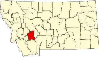
| Staat | Montana | ||
| Coördinaten | 46°10'48"NB, 112°6'36"WL | ||
| Algemeen | |||
| Oppervlakte | 4.297 km² | ||
| - land | 4.291 km² | ||
| - water | 6 km² | ||
| Inwoners (2000) |
10.049 (2 inw./km²) | ||
| Overig | |||
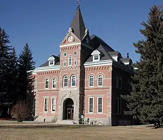
| Zetel | Boulder | ||
| FIPS-code | 30043 | ||
| Opgericht | 1864 | ||
| Website | www | ||
| Foto's | |||
| |||
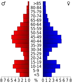 Bevolkingspiramide Jefferson County | |||
| Statistieken volkstelling Jefferson County | |||
| |||
Jefferson County is een county in de Amerikaanse staat Montana.
De county heeft een landoppervlakte van 4.291 km² en telt 10.049 inwoners (volkstelling 2000). De hoofdplaats is Boulder.
Bevolkingsontwikkeling
| Jaar | Inwoners | % ± | |
|---|---|---|---|
| 1900 | 5.330 | — | |
| 1910 | 5.601 | 5,1% | |
| 1920 | 5.203 | −7,1% | |
| 1930 | 4.133 | −20,6% | |
| 1940 | 4.664 | 12,8% | |
| 1950 | 4.014 | −13,9% | |
| 1960 | 4.297 | 7,1% | |
| 1970 | 5.238 | 21,9% | |
| 1980 | 7.029 | 34,2% | |
| 1990 | 7.939 | 12,9% | |
| 2000 | 10.049 | 26,6% | |
| Bron: (en) Historical Decennial Census Population | |||