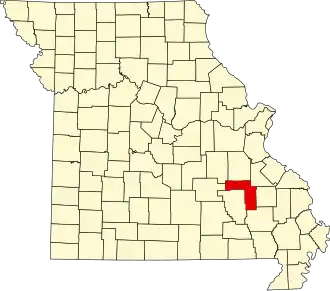
Iron County (Missouri)
| County in de Verenigde Staten | |||
|---|---|---|---|
| |||
| Situering | |||
| Staat | Missouri | ||
| Coördinaten | 37°33'0"NB, 90°45'36"WL | ||
| Algemeen | |||
| Oppervlakte | 1.430 km² | ||
| - land | 1.428 km² | ||
| - water | 2 km² | ||
| Inwoners (2000) |
10.697 (7 inw./km²) | ||
| Overig | |||
| Zetel | Ironton | ||
| FIPS-code | 29093 | ||
| Opgericht | 1857 | ||
| Website | ironcountymo | ||
| Foto's | |||

| |||
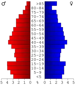 Bevolkingspiramide Iron County | |||
| Statistieken volkstelling Iron County | |||
| |||
Iron County is een county in de Amerikaanse staat Missouri.
De county heeft een landoppervlakte van 1.428 km² en telt 10.697 inwoners (volkstelling 2000). De hoofdplaats is Ironton.
Bevolkingsontwikkeling
| Jaar | Inwoners | % ± | |
|---|---|---|---|
| 1900 | 8.716 | — | |
| 1910 | 8.563 | −1,8% | |
| 1920 | 9.458 | 10,5% | |
| 1930 | 9.642 | 1,9% | |
| 1940 | 10.440 | 8,3% | |
| 1950 | 9.458 | −9,4% | |
| 1960 | 8.041 | −15,0% | |
| 1970 | 9.529 | 18,5% | |
| 1980 | 11.084 | 16,3% | |
| 1990 | 10.726 | −3,2% | |
| 2000 | 10.697 | −0,3% | |
| Bron: (en) Historical Decennial Census Population | |||