Huntingfield
| Civil parish in Engeland | |||
|---|---|---|---|
 | |||
| Situering | |||
| Regio | East of England | ||
| Graafschap | Suffolk | ||
| District | Suffolk Coastal | ||
| Coördinaten | 52° 19' NB, 1° 26' OL | ||
| Algemeen | |||
| Inwoners | 193 | ||
| Overig | |||
| ONS-code | E04009419 | ||
| Foto's | |||
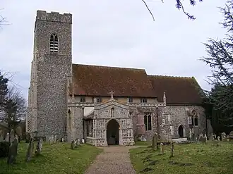
| |||
| Mariakerk | |||
| |||
Huntingfield is een civil parish in het bestuurlijke gebied Suffolk Coastal, in het Engelse graafschap Suffolk. In 2001 telde het civil parish 193 inwoners.[1] Huntingfield komt in het Domesday Book (1086) voor als 'Huntingafelda' / 'Huntingafelde'.[2]
Bronnen
- ↑ Neighbourhood Statistics[dode link]
- ↑ The Domesday Book online