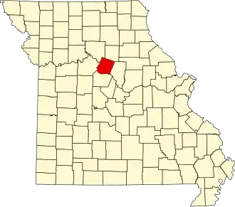
Howard County (Missouri)
| County in de Verenigde Staten | |||
|---|---|---|---|
| |||
| Situering | |||
| Staat | Missouri | ||
| Coördinaten | 39°8'24"NB, 92°42'0"WL | ||
| Algemeen | |||
| Oppervlakte | 1.218 km² | ||
| - land | 1.206 km² | ||
| - water | 12 km² | ||
| Inwoners (2000) |
10.212 (8 inw./km²) | ||
| Overig | |||
| Zetel | Fayette | ||
| FIPS-code | 29089 | ||
| Opgericht | 1816 | ||
| Foto's | |||

| |||
 Bevolkingspiramide Howard County | |||
| Statistieken volkstelling Howard County | |||
| |||
Howard County is een county in de Amerikaanse staat Missouri.
De county heeft een landoppervlakte van 1.206 km² en telt 10.212 inwoners (volkstelling 2000). De hoofdplaats is Fayette.
Bevolkingsontwikkeling
| Jaar | Inwoners | % ± | |
|---|---|---|---|
| 1900 | 18.337 | — | |
| 1910 | 15.653 | −14,6% | |
| 1920 | 13.997 | −10,6% | |
| 1930 | 13.490 | −3,6% | |
| 1940 | 13.026 | −3,4% | |
| 1950 | 11.857 | −9,0% | |
| 1960 | 10.859 | −8,4% | |
| 1970 | 10.561 | −2,7% | |
| 1980 | 10.008 | −5,2% | |
| 1990 | 9.631 | −3,8% | |
| 2000 | 10.212 | 6,0% | |
| Bron: (en) Historical Decennial Census Population | |||