Horton (Gloucestershire)
| Civil parish in Engeland | |||
|---|---|---|---|
 | |||
| Situering | |||
| Regio | South West England | ||
| Graafschap | Gloucestershire | ||
| District | South Gloucestershire | ||
| Coördinaten | 51° 34' NB, 2° 20' WL | ||
| Algemeen | |||
| Oppervlakte | 14,5015 km² | ||
| Inwoners (2011) |
355 (24 inw./km²) | ||
| Overig | |||
| Postcode(s) | BS37 | ||
| Netnummer(s) | 01454 | ||
| Grid code | ST726822 | ||
| Post town | BRISTOL | ||
| ONS-code | E04001057 | ||
| Foto's | |||
| |||
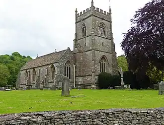
| Kerk van Horton | |||
| |||
Horton is een civil parish in het bestuurlijke gebied South Gloucestershire, in het Engelse graafschap Gloucestershire.
Geplaatst op:
11-8-2010
11-8-2010
Dit artikel is een beginnetje over landen & volken. U wordt uitgenodigd om op bewerken te klikken om uw kennis aan dit artikel toe te voegen.